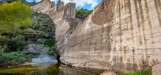
The dam Malpasset
- A historic tragedy: the failure of the Malpasset Dam in 1959 sent a 40-metre-high wave surging down, devastating the Fréjus valley and killing 423 people in a matter of minutes.
- A place of remembrance and reflection: the remains of the burst dam, scattered concrete blocks and the surrounding nature still bear witness today to the violence of the disaster.
- A place to visit and explore: walking trails, mountain-bike rides and guided tours let you understand the dam's history and enjoy the natural setting of the Estérel massif.
Published on 25 January 2022 · Updated on 6 July 2026 · 5 min read
A major disaster in our country's history, the failure of the Malpasset Dam in 1959 left a lasting mark onFréjus. The 40-metre-high wave that surged down the valley to the sea swept away everything in its path, claiming several hundred lives. The collapse of the Malpasset Dam ranks among the most destructive disasters of its kind, like other large dams built to feed hydroelectric power plants. Dams built across rivers to hold back millions of cubic metres of water must be extremely strong and soundly built.
A dam built for irrigation
Planned after the Second World War, the dam upstream of Fréjus was intended first and foremost to create a water reserve for the steady irrigation of local crops. It was built at the place known as Malpasset, on the Reyran river. The Reyran is a torrent with an irregular flow, flooding in winter and drying up in summer. The arch dam was inaugurated in 1954. Its filling nonetheless remained partial for several years, owing to the low rainfall but also to legal proceedings that delayed the dam's commissioning. The year 1959, by contrast, was very wet. The reservoir level rose quickly, preventing a gradual, controlled filling of the site. In early winter, torrential rains brought the dam to its maximum capacity. Downstream, the motorway was under construction and the concrete piers of the motorway bridge had just been poured. The floodgates could not be opened without risking flooding the worksite below the dam. Despite the site managers' decision to release part of the retained water from 6 p.m., the dam gave way at 9:13 p.m. under the pressure of millions of cubic metres of water.
The disaster of 2 December 1959
The dam's failure unleashed a destructive wave more than 40 m high, which drowned the valley in its path and claimed 423 lives in barely 20 minutes. The water surged all the way to the sea through the centre of Fréjus, tearing up kilometres of railway lines and engulfing around fifty farms along the way.
Why did the dam give way?
The failure is attributed to the collapse of the rock wedge beneath the left-bank abutment: undetected faults in the gneiss meant the arch was not resting on homogeneous rock.
The Malpasset site today
A witness to this unprecedented deadly disaster on French soil, the Malpasset site still holds the remains of the burst dam. A place of remembrance and reflection, it is a spot where nature is gradually reclaiming its rights over monumental blocks of concrete, carried by the water like insignificant pebbles for several kilometres. The calm of the place contrasts with the violence of the disaster.
Visiting the dam: access and hikes
Walking trails and mountain-bike rideslet you reach the foot or the top of the dam. In season, guided tours of the Malpasset site are offered on Tuesday mornings. The meeting point is in front of the tourist office, and access to the site car park is then by car. These tours explain the technical features of the arch dam, retrace how the disaster unfolded and discuss its causes. They are also a chance to enjoy a pleasant walk inthe Estérel massif, in a calm atmosphere conducive to reflection.
Tip from the Tikayan team: park in the car park under the motorway bridge; a trail of about 1 km leads to the foot of the dam. Good shoes and water are recommended in summer.
To explore the site freely, visitors have several options: from the car park located under the motorway bridge, a 1 km trail leads to the foot of the dam, another to the heights. A 5 km hike also offers a loop taking in both the scenery at the foot of the dam and the viewpoint overlooking the structure. The Reyran, whose flow varies greatly, should be watched in the event of heavy rain in the hours or days before any visit to the site.
The Fréjus arch dam is also the destination or one of the stages of several mountain-bike routes in the massif.
During your visit to Fréjus, also discover theFréjus zoo, an ideal outingwith the family. For accommodation, theLa Vallée du Paradis campsiteinAgayand theLes Cigales campsitein Le Muy are perfectly located toexplore the area.
Good to know: the site is above all a place of remembrance (423 victims in 1959). Guided tours are offered on Tuesday mornings in season.
FAQ: the Malpasset dam
What happened at the Malpasset dam in 1959?
On 2 December 1959, the arch dam gave way. A 40-metre wave surged down the Reyran valley to the sea and killed 423 people in about twenty minutes.
Why did the Malpasset dam break?
The failure is attributed to the collapse of the rock wedge beneath the left-bank abutment: undetected faults in the gneiss meant the arch was not resting on homogeneous rock.
How many victims did the disaster claim?
423 dead according to the official toll, and around 7,000 people affected.
Can you visit the Malpasset dam today?
Yes. The remains of the burst dam can be seen in the Reyran valley. Guided tours are offered in season by the Fréjus tourist office.
How do you get to the Malpasset site?
From the car park under the motorway bridge, a trail of about 1 km leads to the foot of the dam. The site is also a stage on hiking and mountain-bike routes in the Estérel massif.
Where is the Malpasset dam?
Upstream of Fréjus, in the Reyran valley, at the gateway to the Estérel massif.

Solène Bonati, Tikayan team
Part of the Tikayan team, Solène knows the ground of our campsites in the Var, Provence and on the French Riviera. Here she shares her tips to plan your stay and make the most of the Fréjus area.